About Field Topography UTM free
Topographical calculations for UTM. Grid on the map. Calculations in full or brief coordinates, in one or in the adjacent zones. Rectangular coordinates in meters. Altitude, range in meters. All angles on scale 64-00 or...
Topographical calculations for UTM. Grid on the map.
Calculations in full or brief coordinates, in one or in the adjacent zones.
Rectangular coordinates in meters. Altitude, range in meters.
All angles on scale 64-00 or 60-00 (settings option on main screen).
In DGP and IGP angles are available in degrees - minutes – seconds.
GPS location in rectangular coordinates.
Azimuth of the Sun, the Polaris in specified time.
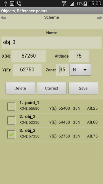
Maintain a list of objects that may be used in which the tasks (250). In free ver. - 3.
Read / write and append data from a file. The data file may edit/prepare a text editor, transfer methods available.
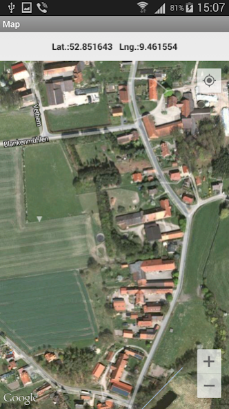
Google Maps, ArcGIS, MapBox, prepared ofline-atlases with markers points from the list (only with full coordinates).
Atlases in the format *.mbtiles can be created in SAS Planet, MobAC. Based on osmdroid.
UTM-Grid on the map.
When you touch the marker shows the number and name of the point.
When you touch the map shown rectangular coordinates of the location.
Maps are cached (accumulated) to work without a network.
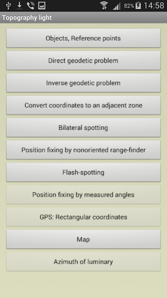
Tasks list:
Direct geodetic problem;
Inverse geodetic problem;
Convert coordinates to an adjacent zone;
Localizing with paired observation (readout from the base or directions);;
Binding undirected rangefinder (range up to 2 known points);
Binding by measured angles(between the left-middle and middle-right known points with anchor points);
Binding according to GPS (geodetic and rectangular);
Azimuth of luminary;
Localizing with a stopwatch (with the air temperature);
Map.
Settings:
- Maps ( Google / ArcGIS / MapBox / prepared offline-atlases);
- The scale of thousandths (60-00 , 64-00)
- Color style
- The type of map (topographic, satellite, hybrid)
- Type of marker points on the map
- Grid on the map (no , 1km , 2 km )
- Save data to a file, read / write and append data from a file.
The program is distributed "as is". Its use - discretion and responsibility of the user.
All tasks and all the features available in the full version.
The free version has some ads.
Previous Versions
Here you can find the changelog of Field Topography UTM free since it was posted on our website on 2016-11-03 21:05:36.
The latest version is 2.8.1 and it was updated on 2024-04-19 23:49:35. See below the changes in each version.
Field Topography UTM free version 2.8.1
Updated At: 2022-02-20
Changes: +MGRS.
Field Topography UTM free version 2.8.0
Updated At: 2022-02-06
Changes: Added offline work with prepared atlases. Based on osmdroid.
Atlases in the format *.mbtiles can be created in SAS Planet, MobAC.
+MGRS.
Field Topography UTM free version 2.7.0
Updated At: 2021-11-11
Changes: Added offline work with prepared atlases. Based on osmdroid.
Atlases in the format *.mbtiles can be created in SAS Planet, MobAC.
The free version has some ads.
Field Topography UTM free version 2.5.1
Updated At: 2020-08-30
Changes: Added offline work with prepared atlases. Based on osmdroid.
Atlases in the format *.mbtiles can be created in SAS Planet, MobAC.
Field Topography UTM free version 2.3.1
Updated At: 2020-01-10
Changes: Added offline work with prepared atlases. Based on osmdroid.
1. Place for the atlas - Offline Maps folder in the program folder
2. Atlases in the format *.mbtiles can be created in SAS Planet, MobAC.
Field Topography UTM free version 2.2.0
Updated At: 2019-11-26
Changes: The choice of the location of the stored data files is the program / device memory.
Choosing the format of the stored data - txt / xml
Field Topography UTM free version 2.1.3
Updated At: 2019-06-11
Changes: Added a new kind of point marker (with the item number in the list)
Field Topography UTM free version 1.2.2
Updated At: 2016-10-24
Disclaimer
Official Google Play Link
We do not host Field Topography UTM free on our servers. We did not scan it for viruses, adware, spyware or other type of malware. This app is hosted by Google and passed their terms and conditions to be listed there. We recommend caution when installing it.
The Google Play link for Field Topography UTM free is provided to you by apps112.com without any warranties, representations or guarantees of any kind, so access it at your own risk.
If you have questions regarding this particular app contact the publisher directly. For questions about the functionalities of apps112.com contact us.